 |
| From Manakau to Bluff and back again. |

Roadtrip Chris Arbon : A KTM Adventure
Showing posts with label New Zealand Cycle Tour 2010-2011. Show all posts
Showing posts with label New Zealand Cycle Tour 2010-2011. Show all posts
Sunday, February 27, 2011
The Last Days of the NZ Cycle-Tour.

____From Whitianga, a small passenger ferry took me and the bike across the harbour entrance to Cooks Beach. Saving a lot of time and energy; leaving me with a short ride to Cathedral Cove with it's spectacular sea caves. Due to landslides, inspection on foot wasn't allowed; kayaking from the beach along to the caves seemed to be the way to see them. Hot Water Beach was just down the coast and had it's own adjacent campground. At low tide, fresh water, heated by molten rock far below the Earth's surface, seeps through the sand in two places at 60 degrees C. People dig holes in the sand and bathe in the hot water; I walked through some abandoned diggings just before the tide came back in. I heard later that during the previous night, low-tide at been at mid-night and people had bathed under the light of a full moon.
____Riding distances are getting shorter as the trip comes to an end and I try and time my arrival back at the airport. Even so, everyday seems to have two or three long hard climbs as the rugged terrain of the Coromandel Peninsula continues. Opertere is my next stop, more of a beach than a village. But what a beach, pure white sand 4 kilometres long, backed by dunes leading through to pine woods. A paradise for surfers with relentless rollers crashing ashore direct from the full width of the Pacific Ocean. Not good for swimming as a powerful rip constantly tears your feet from under you. But good for jumping about in the surf and getting clean; especially as the campsite showers were out of action due to a broken pump.
____Into Whangamata for a Sunday morning breakfast at a buzzing seaside town. Then on to Waihi as I leave the Coromandel behind. Beautiful countryside and a warm climate; I've enjoyed it even if the cycling has been some of the hardest of the trip. I'm glad I left it to last, I did contemplate going round the peninsula in my first week before I had attained any reasonable level of fitness; that would have been a killer.
____Finally back on to the flat Hauraki Plain, now retracing the tyre tracks of my first days on the bike. Camping at Miranda Hot Springs Campground, where a $22 tent site includes access to a hot pool. A maximum of thirty minutes is all that's needed before I go all wrinkly. So enjoyable, that I go in for another dip in the morning but now I have swimming trunks that smell of sulphur.
____Opere Point was my first night under canvas and I'm back again at the same site. Camped early and lazing ,as usual, in the most comfortable seating available; the television lounge. Someone comes in and switches on the telly; the earthquake at Christchurch had just happened. I'm as shocked as everyone else to see a city centre, that I had rode through only a few weeks earlier, totally devastated.
____The earthquake seems to have shaken everybody in New Zealand. A small country with a major disaster to cope with. My spirits are dampened for the rest of the trip. Two nights at Manakau, the nearest camping to Auckland airport. The flights are all on time and I bring the bike back to Canada without any hassle but I have an overall feeling of sadness on leaving New Zealand at what everyone is calling it's darkest days.

Wednesday, February 16, 2011
Coromandel Peninsula.

____The flat landscape of countless dairy farms continues throughout the day as I head north-west towards the Firth of Thames and the town of the same name. At Paeora, I stumble upon a Highland Tattoo in full swing; I nearly throw up in my mouth. Thames brings me back to the coast and the area known as the Coromandel Peninsula; the first campsite on the sheltered western shore is Dickson’s. Three kilometres on from town with a Butterfly and Orchid enclosure on site; if you like that’s ort of thing.
____Almost every vehicle passing me, northbound on a Sunday morning, is towing a boat. It’s a narrow, twisting road; right on the shore with just a few metres of rocks and sand shaded; by old native trees clinging to the cliff face. A nice level ride half way to Coromandel Town; before two headlands jutting out to sea force the road inland and up and over a couple of long winding climbs.
____ I camp at the “Tidewater”; a neat and tidy place that takes a scattergun approach to tourists and caters for campervans, tents, has cabins and motel units for rent plus dormitories for backpackers. A fully equipped kitchen and comfortable lounge area persuade me to stay four nights; my longest layover of the tour. I think I deserve a break.
____There is a varied crowd of travellers in the Tidewater every night; always friendly. A run up the coast to Colville Bay and back takes up most of one day; also exploring the town and the various nearby beaches takes another day; the third day was non-stop rain.
____ Out of Coromandel Town and straight up into the hills that are the spine of the peninsula; as difficult ascent as any on the tour. It’s only 41 kilometres to the west coast town of Whitianga but that’s enough for one day. Hot and sunny with a strong sea breeze, Whitianga doesn’t seem to have the same atmosphere as Coromandel; probably trying too hard to be up-market.
Thursday, February 10, 2011
Oakura to Te Aroha

____From Oakura it’s a short ride to the busy port of New Plymouth, the largest town since Wellington. Back on Highway 3, it is much busier with a lot of trucks making their way to and from Auckland. The level terrain finishes with the stiff climb over Mount Messenger, then ups and downs along the cliffs to Mokau. A night at the Whitebait Inn, which has a grassy area at the back for tents and does good fish and chips.
____Starting off at sea-level and heading inland; I know I’m in for a day of climbing. The Awakino River Gorge delays it for the first hour but soon the road climbs out of the steep tree-lined valley on to rolling hills of grassland. The area is called the King Country, after the stronghold of the Maori kings. I camp at Te Kuiti, the town that was the old capital.
____The weather is much more humid as I cycle north; the nights are not chilling down and although there is constant cloud cover and little sunshine, I still have to use plenty of sunscreen due to the depleted ozone layer above New Zealand. Hamilton looks like a hard days ride from Te Kuiti; so I settle for Te Awamutu, camped among a whole load of polo pony people; without ponies.
____A short days ride up to Hamilton, New Zealand’s largest inland city and fourth overall. I cannot believe a town this size can warrant so many coffee houses in the downtown area; none of them looked busy and they all looked too pricey. However, the city centre campsite was shady, clean and reasonable.
____Flat arable farmland from Hamilton, north-east on Highway 26 to Te Aroha. With a break at Morrinsville; I’m still camped out by 2 o’clock. Just in time as the wind gets up and the rain comes in over the hills to the east.

Sunday, February 6, 2011
Wellington to Oakura.

____At Bulls, I leave Highway 1 for Highway 3; still much of the same flat pastures but with rain and a headwind it’s a hard slog to Wanganui. The New Zealand Masters Games have just started in town and fearing hiked prices and a shortage of space; I push on along the coast to the Kai Iwi Beach at Mowhanau for a pretty much deserted campsite.
____More rain, but with breaks at Waverley and Patea, the weather finally clears by the time I get to Hawera. For three days, loaded milk tankers have been pouring past me with monotonous regularity, all heading for Fonterra’s Hawera depot. The biggest dairy products plant in the country; taking in over 20% of New Zealand’s milk. Tomorrow, I will have empty tankers coming past as they leave to fetch more milk. There is a good municipal campsite at Hawera but no spare cabins; so the wet tent is erected again, now smelling like a wet dog.
____Dry roads, but still low cloud with no sign of Mount Taranaki putting in an appearance. Highway 45, the Surf Highway, as I take the long way round the mountain. It is flat, but at about two fields back from the shore, it is not as picturesque as it could be. Opunake is the only seaside town in the 90 kilometres before Oakura and a tent site that is the last piece of grass before the black sand of a well used surf beach. But I’m getting used to the sound of breakers as I go to sleep.
Sunday, January 30, 2011

Friday, January 28, 2011
Nelson.

____From Charleston to Westport, a short day and a tent site at Carters Beach; where I leave the panniers and go into town before riding out to the lighthouse at Cape Foulwind. Named by Captain Cook; it probably can be a bit rough on a bad day, but when I was there, it was sunshine and a light breeze. Well over a week of fine weather on the west coast. Westland, so shortened to Wetland.
____A long day along the banks of the Buller River, from Westport; sea-level, to Murchison at a elevation of 208 metres in 106 kilometres. The first 26 miles being the course of the Buller Marathon, running down stream.
____More bankside riding by the Buller to start the day from Murchison but then a long winding climb over the Hope Saddle; a higher crossing of the Southern Alps than the Haast Pass. A steep twisting descent has the brake pads smelling hot; then twenty kilometres downhill in top gear to the rustic camping called Quinneys at the small township of Motupiku.
____Another saddle on Highway 6, Spooners Saddle, before Nelson. But a fine cycle track alongside the coast, from Richmond into the heart of Nelson’s port area. A compact little town with plenty of cyclists out and about in the sunshine. Laundry needs to be done; so I book two nights at the Nelson City Motor Camp, small but close to the town centre. The first rain since leaving Haast comes during the night; but the morning dawns clear and bright, if a little windy.
 |
| A bar dedicated to a truck marque. |
Monday, January 24, 2011
Charleston, Westland, NZ.

____A 100 kilometre day to the seaside town of Hokitika. A tail wind and a lot flatter as the farms now have most of the narrow coastal plain cleared of bush. Tea-breaks at Harihari, Pukekura and at Ross, the historic gold town. Pukekura’s Bushman Centre being the original “Roadkill Café” with possum being the most popular. All the benches are covered with possum fur.
____Away from Hokitika and to Kumara Junction, where the two Spanish guys turn off to tackle Arthur’s Pass; on there way back to Christchurch. I’ve seen a lot of them during the last week and we are on first name terms. They are both called Jose; I christened them “Jose Juan” and “Jose Too”, but didn’t mention it. I carry on north, through Greymouth, replenishing supplies and onto the beachside camping at Rapahoe. The old village school converted into a camping ground without losing the schoolroom atmosphere; amazing place.
 |
| The Pancake Rocks |
 |
| Mt. Tasman and Mt. Cook reflected in Lake Matheson. |
Thursday, January 20, 2011
Fox Glacier

____Thirty kilometres to Fox Glacier and after breakfast, I explore the tracks leading to the ice-mass; on foot to the Chalet Viewpoint is the most rewarding. A stiff climb with rock-hopping to cross several creeks finishes on a platform high above the point where the ice melts and the Fox River starts. Fox Glacier Village is purely for tourists to visit the ice but I’m pleasantly surprised to get a site for my tent for only NZ$17. For the second day running the famed Westland rainfall has contented itself to a couple of showers. However, there are plenty of the dreaded sandflies about.

Tuesday, January 18, 2011
Queenstown to Haast
____Away from Frankton at 7 o’clock ready for a long day to Wanaka; firstly following the Kanwarau Gorge as it takes the waters of Lake Wakatipu down to Cromwell. Down hill amongst the vineyards before turning north along the west shore-line of Lake Dunston and it’s cherry orchards. Into a headwind and not a pub or café for over 100 kilometres. A night at the Southern Matterhorn Backpackers, a reference to the pinnacle shape of nearby Mount Aspiring, in Downtown Wanaka; a kind of mini-Queenstown.
____Another day of constant head wind, from Wanaka to the banks of Lake Hawea before changing to the banks of Lake Wanaka for the northward slog to Makarora. Two Spanish guys catch me up, also cycling to Makarora. One has a profile map book showing all the hills that are to come. The other has GPS on his camera and knows exactly how far we have to go; but neither has a substitute for pushing the peddles round and getting us there any easier.
____A big day riding over the Haast Pass, one of three road crossings of the Southern Alps of New Zealand. Up to a height of 564 metres and after only twenty minutes out of Makarora; it starts pouring with rain. Soaked through and with no place to shelter, I push on over the top in Westland. At Pleasant Flat Shelter comes a place to rest but it’s full of cyclists from a tour company having lunch spread out for them at the only picnic table.
“ On days like this we’re all in it together,” says the tour guide lady, “ help yourself to sandwiches and fruit.”
That’s all the encouragement I need to start hoovering up what the wet and bedraggled cycling tourist don’t need. They are having their bikes loaded on to the top of their minibus and are going over to Makarora in the warm and dry. From the rest area, I push on, non-stop, to the township of Haast and book into the warm and dry Wilderness Backpackers.
____Julius Von Haast gave his name to the Haast Pass in the 1860’s. along with the Haast River, Haast Junction and the Gates of Haast; the road was first opened to vehicles in the 1960’s. Herr Haast’s other great claim to fame is that he once bought a genuine Egyptian mummy for only $24. I would have loved to have been there when he rolled up at an Antiques Roadshow with that little beauty.
  |
| Dos Amigos |
____Another day of constant head wind, from Wanaka to the banks of Lake Hawea before changing to the banks of Lake Wanaka for the northward slog to Makarora. Two Spanish guys catch me up, also cycling to Makarora. One has a profile map book showing all the hills that are to come. The other has GPS on his camera and knows exactly how far we have to go; but neither has a substitute for pushing the peddles round and getting us there any easier.
____A big day riding over the Haast Pass, one of three road crossings of the Southern Alps of New Zealand. Up to a height of 564 metres and after only twenty minutes out of Makarora; it starts pouring with rain. Soaked through and with no place to shelter, I push on over the top in Westland. At Pleasant Flat Shelter comes a place to rest but it’s full of cyclists from a tour company having lunch spread out for them at the only picnic table.
“ On days like this we’re all in it together,” says the tour guide lady, “ help yourself to sandwiches and fruit.”
That’s all the encouragement I need to start hoovering up what the wet and bedraggled cycling tourist don’t need. They are having their bikes loaded on to the top of their minibus and are going over to Makarora in the warm and dry. From the rest area, I push on, non-stop, to the township of Haast and book into the warm and dry Wilderness Backpackers.
____Julius Von Haast gave his name to the Haast Pass in the 1860’s. along with the Haast River, Haast Junction and the Gates of Haast; the road was first opened to vehicles in the 1960’s. Herr Haast’s other great claim to fame is that he once bought a genuine Egyptian mummy for only $24. I would have loved to have been there when he rolled up at an Antiques Roadshow with that little beauty.
Saturday, January 15, 2011
Queenstown.

____A cycle track leads from the campsite; the eight kilometres into the heart of Queenstown, hugging the lake shore all the way. The town must hold the record for the most outdoor pursuit shops per square kilometre in the world. Activity is what Queenstown is all about; that and spending money. From bungee jumping, sky-diving, white water rafting to jet boating and canyoning; it’s all on offer. Plus hiking, sight-seeing and a lake cruise on the old steam ship; MSS Earnslaw. But with a budget of NZ$60 per day; I’m left with browsing the sports shops; wondering who buys all this hi-tech, light-weight, quick-drying, non-sweating clothing that is so bloody expensive.
____Window shopping is not my main reason for two nights at Queenstown. My next stop is at Wanaka and they are having their annual Ironman triathlon event with 1200 competitors. It would be good to watch it; but as all the accommodation is booked up, I’ll leave my arrival until everyone has gone home. I’m not a big fan of these extreme events, 3.8 km swimming, 180 km cycling and then a marathon run. What are the joints of these athletes going to be like when they reach old age? I’ve seen bodies ruined by hard work such as bricklaying and plastering; so with the endless training, these triathletes are heading the same way.
 |
| Lake Wakatipu |
Thursday, January 13, 2011
Northbound.

____ Leaving most of my luggage at the backpacker hostel for the day, I have an easy lightweight ride down to the final kilometre of Highway 1 at Bluff. A port for the shipping of lumber, containers and aluminium; it is also the ferry terminal for the trip to New Zealand's third biggest island. But it's NZ$132 return to Stewart Island and as they don't have many roads; I decide against a choppy boat trip. I satisfy myself by viewing the island from the Lands End signpost while getting a young lady from Southend-on Sea to take my picture. Then it's back to Sparky's for another night and more chocolate cake.
____ North from Invercargill, through Wilton and on to Lumsden with a new haircut and the wind behind me. Lumsden's campsite is deserted; reminding me of all those municipal camps in small French country towns. The big difference is that Lumsden has a fully equipped kitchen with most of the stuff brand new. By nightfall there are three of us, one on foot, one car and me on the bike; nobody shows up to collect any money so we put it in the honesty box. I can think of quite a few places where the honesty box would have disappeared, along with most of the kitchen.
____The flat plain of Southland continues for much of the morning and at Five Rivers I meet a Canadian couple from Gatineau, cycle touring, also heading for a overnight stop at Kingston. I'm surprised how much quicker they are than me; but with their narrow tyred racing bikes, it's not a style of riding I am comfortable with. The mountains slowly close in on the road when I reach Otago but there are no real climbs before the small lakeside town of Kingston and a friendly motorcamp, cafe and pub.

Tuesday, January 11, 2011
Invercargill and the World's Fastest Indian.
_____ Invercargill first came to my attention when I saw the Sir Anthony Hopkins' movie: The World's Fastest Indian, where he plays the character of Bert Munro. Bert owned ,rode and modified a 600 cc. Indian motorcycle that he bought in 1920 until in 1967 he took it to Bonneville Salt Flats in Utah and got it to go at over 200 miles per hour. A great film well worth getting out on DVD.
_____ Bert's original bike is still in Invercargill, at Hayes' hardware store and the replica bike used in the film is on show at the museum. Oreti beach, where Bert did a lot of speed trials is just down the road. I stayed at Sparky's Backpackers and made Sparky put the film on; even though he had seen it over fifty times. Then the guy keeps coming in from the kitchen with various bits and pieces that he tells me are props from the film. The place to watch it, bar none.


_____ Bert's original bike is still in Invercargill, at Hayes' hardware store and the replica bike used in the film is on show at the museum. Oreti beach, where Bert did a lot of speed trials is just down the road. I stayed at Sparky's Backpackers and made Sparky put the film on; even though he had seen it over fifty times. Then the guy keeps coming in from the kitchen with various bits and pieces that he tells me are props from the film. The place to watch it, bar none.


Sunday, January 9, 2011


Southern Otago

____Alexandra finishes my Otago Central Rail Trail after a couple of hours down from Omakau. Back on the road, southbound to Roxburgh, where I have two punctures in quick succession. The back tyre had taken a tremendous pounding on the dirt trail and shows signs of broken cords. Alongside the Clutha river are many orchards with picking of apricots and cherries in full swing. The camp site at Ettrick has plenty of casual seasonal workers and the pub next door is buzzing on a Saturday night.
____I change the tyres from back to front; hoping to nurse the bike down to Gore for a re-fit. But another puncture soon takes my last patch. The hottest day of the tour and 15 kilometres from Gore, the tyre goes flat again; now I have to get off and push. After 5kms a pick-up truck stops and a good guy who does plenty of mountain bike riding loads up my bike and runs me into town; right up to the camp site. Thanks Mate, I owe you one.
Wednesday, January 5, 2011
The Otago Central Rail Trail.
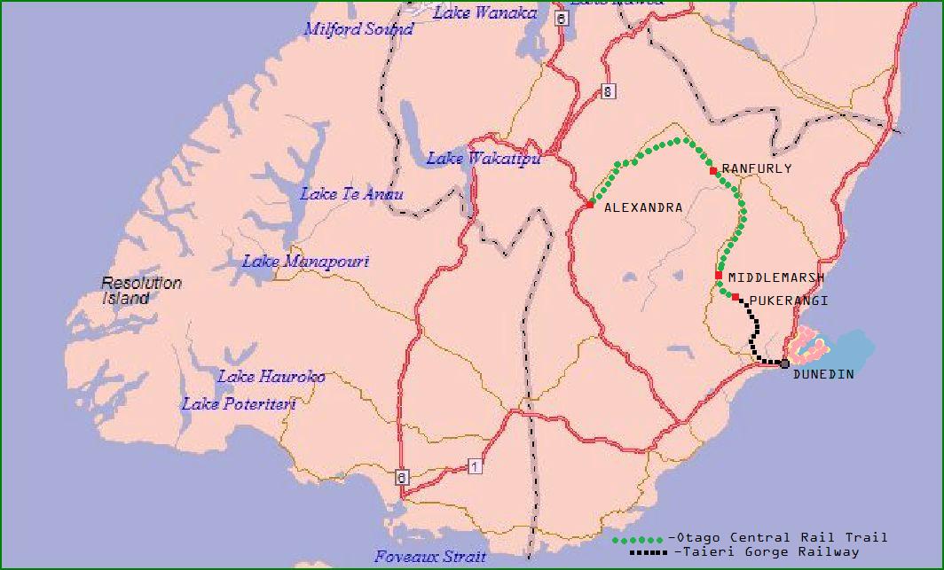
____Rain all day which spoils an awesome ride along the old pathway of the tracks that are a continuation of the line that brought me up from Dunedin. It is hard packed gravel which seems to drain remarkably well as there are few puddles and very little mud. It’s a busy trail with a lot of cycle tour companies doing packages for tourists; not many kitted out for carrying luggage; as many have their bags transported for them. A cup of tea at the old station house at Hyde and onto overnight accommodation at The Old PO Backpackers at Ranfurly.
Tuesday, January 4, 2011

The Coastline of Otago.
 |
| On the beach at All Day Bay. |
 |
| The Boulders at Moeraki. |
 |
| Two metre diameter rock spheres. |
 |
| Moeraki Harbour. |
 |
| Cornish Head, north of Karitane Bay, Otago. |
Ashburton to Dunedin.

____ The flat road riding comes to an end when Canterbury turns into Otago. Also at Glenavy, the rain returns. I rent a cabin for the night at Oamaru, a remarkable town of splendid limestone buildings that seem unjustified by it’s size. A handy quarry with quality white stone and the proceeds of a long gone gold-rush are the reason for the unexpected architectural extravagance.
____ A wet morning dries by the time I reach All Day Bay, as the coast road switches between the beach and the cliff top. It’s hard going, after the flat roads of Canterbury, only compensated by an excellent fish and chip lunch at “Lockie’s” in Hampden. I knew it would be could when I saw the queue, a sure sign of a good chippie, the world over. An early finish, as I camp at Moeraki and head off along the beach to investigate the Moeraki Boulders; the Maltesers of the Gods, according to Maori legend.
____Moeraki to Dunedin and probably the hardest day on the bike so far. Beautiful coastal scenery on minor roads that twist and turn; climb and swoop. It’s signposted as a cycle route to Dunedin and as the Highway 1 is closed to bicycles, it’s the only way to go. Mount Cargill Road is long and winding but then drops me down into the city at the speed of sound. I book into an hotel for the night, quite near the city centre; in the morning I have to be up early because I have a train to catch.

Thursday, December 30, 2010
The Canterbury Plains.

____ From Christchurch across the plain to Ashburton on a fine sunny day with just a slight headwind. Across the longest bridge in New Zealand at Rakaia; over a mile long and a narrow two-lane. A lot of NZ bridges are narrow with no provision for cyclists; this calls for special tactics to avoid getting squeezed into the wall. I drive in the middle of my lane; anything wanting to come past must wait for a gap in oncoming traffic and use the other lane. I’m sure it annoys some people but as most of the time I ride on the hard shoulder they have little reason to complain.
____ People are always very friendly; always with a lot of questions. Apart from “Where to?”- “How far?”- “Where from?”; a common question is “ Why New Zealand?” to which I have found the best answer is: “Because I hate Australians.” This is not true but always goes down well. The other popular question is: “How’s your bum?” to which I casually answer, ”Ok.” In fact I know exactly how my bum is; thanks to a digital camera with flash and a laptop on to which I can download and enlarge daily images; I have a good database of how my bum is standing up to the rigours of cycle-touring down-under. If there is any demand from the medical profession reading this; I can easily post pictures for your perusal.
Subscribe to:
Posts (Atom)